Lake George

Lake George
Lake George - from Tongue Mtn Range - 11/11/2011
Showing posts with label Cliff Mountain. Show all posts

Monday, September 1, 2014

Cliff Mountain and Mount Redfield from Upper Works - 9/1/14


This outing was planned by my wife Leesa who is closing in on finishing her Adirondack High Peaks.  She had 43 out of 46, with just Cliff, Redfield and Couchsachraga left.  She had decided long ago that she wanted to finish on Couch, so Cliff and Redfield, being neighbors, were the goal for today.

The weather forecast was good with increasing sunshine predicted.  We got on the trail at 6:30 AM from Upper Works.  I had told her that this would be an 18+ mile day and she preferred to start early rather than finish late.  She hadn't done many hikes recently that were this long, so the plan was to go slow and steady and not burn out too soon.

By 8:30 we were at our adopted lean-to at Herbert Brook, and we stopped to check on it.  Then it was on to the Lake Colden Dam.  We only saw 4 groups of people all day.  One couple was near Flowed Lands and the other 3 groups were near the Colden Dam.  We didn't see anyone along the Opalescent or on Cliff and Redfield.  We had thought we would have seen a lot of people since it was a holiday.   
    
I lifted Rev down the ladder to the Colden Dam by her Ruffwear harness.  (It has been great for that purpose).  Soon we were a the suspension bridge.  The water level was lower than I had expected.  That turned out to be OK, since it made the trail to Cliff less muddy.


Rev had no problem crossing the suspension bridge over the Opalescent River 


Looking upstream from the suspension bridge. 

It was nice to have some clouds in the morning while we were climbing.  The sun came out shortly before we reached the summit of Cliff.  We had chosen to climb Cliff first to save the best for last.   


Clouds leaving and blue skies arriving, late morning!

The mud on the lower section of the herd path to Cliff wasn't nearly as bad as it usually is earlier in the season.  I managed to keep my feet dry all day in my trail runners.

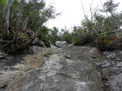
The cliffs on the mid-section of Cliff were challenging as always, and Leesa wasn't a big fan of them.  She was glad on the way down when they were behind us.

We reached the summit around 11 AM and skies were clearing.  The humidity wasn't bad and we had no issues with bugs all day.
     

#44  for Leesa - Cliff Mountain


Leesa coming down Cliff

Leesa enjoyed the herd path to Redfield much more than the herd path to Cliff (who doesn't?).   The water along the Uphill Falls Brook was delightful and we stopped on the way up and on the way down to soak our feet.

She did begin to wear down from the climbing as we neared the halfway point going up Redfield.  We just slowed our pace down and she focused on putting one foot in front of the other to reach #45. 


One of the pools of water on Uphill Falls Brook


Some muddy hiking shoes taking a break...


It was about 3 PM when we reached the summit of Mount Redfield.  The weather was perfect and we were really enjoying Redfield.  We stayed there awhile to eat our late lunch.


# 45 for Leesa - Mount Redfield


Skylight on left, from Mount Redfield


Gray, Marcy and Skylight from Redfield

Around 4 PM we made our last stop to soak our feet in Uphill Falls Brook and then it was time to make tracks to get out by dark.  We passed the Lake Colden dam around 5:15 and Flowed Lands around 5:45.   We got great pictures from both those spots.


Lake Colden from the dam

Leesa was a trooper as we made our way back down the Calamity Brook Trail.  She knew the sooner she got back, the sooner she could get off her feet.  We managed to get back just as darkness was setting in.  We gave Rev her dinner right there in the parking lot and she was asleep before we even got back to Blue Ridge Road.     


Flowed Lands


The Henderson Memorial

Hike Stats:
Hike Distance:  18.9 miles
Hike Time:  13.5 hours
Total Vertical Gain:  ~ 4000'


The route (Click image to enlarge)


Tuesday, February 26, 2013

Cliff, Redfield, Gray and Skylight - 2/26/13

Another wind free mild day for me to take advantage of.  This time I decided to head for Cliff and Redfield Mountains from Upper Works.  I left Schroon Lake at 5:45 and it was 27 degrees.  Somehow when I arrived at Upper Works at 6:30, it was 7 degrees.  It always seems cold there.  Every time I drive that direction, I see my temperature gauge dropping.

In any case, I knew it would warm up.  I was on the trail at 6:35 and I could see the sun just coming up over the mountains.  I was on the Calamity Brook Trail heading towards Flowed Lands.  I believe this trail is my favorite winter approach trail to high peak hiking.  It just feels nice to me, compared to other trails.  In the summer it's quite rocky, but in the winter it's nice.  It's also a great ski route.


Heading north on the Calamity Brook Trail

I was on snowshoes and covered the 4.6 miles to Flowed Lands in 1.5 hours.  Flowed Lands is just a magical place, and on a day with no wind, it's a joy to step out on the ice and cross.  It also saves time as opposed to skirting around on the trail.


The sun just about to rise


Mount Colden and Avalanche pass


Looking Back towards the Calamity Brook Trail


McMartin Leanto

I made my way over to the crib bridge that crosses the outlet of Lake Colden and began climbing the trail alongside the Opalescent River.  In the summer, this area is spectacular.  In winter there is not much to see around the flume.  I reached the suspension bridge at 8:30, crossed the Opalescent and was up at the Uphill Leanto at 9:10, 2.5 hours from Upper Works.


Add caption

I found the snowshoe track from the previous day heading up the herd path to Cliff and Redfield and I followed it.  At the split, I decided to climb Cliff first.  I did Redfield first in the summer and decided that next time I would do Cliff first.  I managed to climb the icy cliffs in my snowshoes by grabbing branches along the way for added security.

Summit of Cliff Mountain

At 9:45 I was on top of Cliff.  There was some visibility and no wind.  It was about 20 degrees.  I stopped to have a snack and explore the different view points, then it was back to the junction for Redfield.  


Views from Cliff


Mount Colden from Cliff

 I forgot how steep and continuous the trail is to Redfield, but at 11 AM I was standing on the summit wondering what happened to the views.  The fog had rolled in and that was the end of my summit views for the day.  Not much to see any longer.


Redfield summit sign and disc


View from Redfield

Although the climb to Redfield was steep, the descent was easy.  I found myself back at the Uphill Leanto at 11:30 and it got me thinking.  If I returned to the car, I would get back at around 2 PM.  I decided I had enough time to head for Gray and Skylight.  I could always head out the Calamity Brook Trail by headlamp if need be.

I continued on the trail along the Opalescent River until the junction with the trail for Lake Tear of the Clouds.  The trail for Lake Tear was the killer of the day after having done Cliff and Redfield.  It is a steep trail for almost the entire 1.2 mile to Lake Tear.

At Lake Tear, I dropped my pack and went up Gray Peak.  Still no views.  I was on the summit of Gray at 1:05 PM.  The fog was getting worse.  I dropped back down, left my pack where it was and headed for Mount Skylight. 
    

Summit sign and disc


Looking from Gray towards Mount Marcy


4 Corners

I had finished my 46 high peaks on Skylight, and it is a fabulous mountain, but today it felt like I was walking on the moon.  It was just white.  White snow, white sky, white cairns.  The cairns were the only feature that was identifiable.  I made my way to the summit rock pile and it was even hard to see my tracks in the snow.  It was now 1:50 PM.


The summit of Mount Skylight.  Nothing was visible.


It was all downhill now.  I made my way back to Uphill Leanto, back to Flowed Lands, then down and out to Upper Works.  Downhill in winter is so much easier.  I signed out at 5:10 PM.   Not bad, 10.5 hours for 24 miles and 4 peaks!  Time for an Advil though...


Lake Tear of the Clouds


Uphill Brook Leanto


Hike Stats:
Hike Distance:  24 miles
Hike Time:  10.5 hours
Total Vertical Gain:  ~ 6000'


My route for the day (Click image to enlarge)


A topo of the route

Saturday, June 2, 2012

Cliff Mountain and Mount Redfield - 6/1/12

I must confess that I now have the bug to finish climbing the 46 Adirondack High Peaks this year.  I really wasn't feeling the urge earlier in the year, but now that I am 2/3 done (32/46) I will probably push to finish.  I will, however, wait for the right weather.  I want to be able to enjoy the summits and get the views, and not just check off a summit.

Yesterday, my choice for a hike was Cliff Mountain and Mount Redfield.  Rev and I were gearing up for a big day on Friday.  Scatterbone also needed these peaks and joined us for the hike.  We met at the Upper Works trailhead at 6:30 AM and were quickly on the trail.  The weather forecast was generally good for the morning, with increasing cloudiness for the afternoon and a 30 % chance of showers late in the day.  It was cool, with temps in the low 40's in the morning and upper 60's in the afternoon.


Looking towards Avalanche Pass and Mount Colden from the Colden Lake bridge.

We quickly made the 4.5 mile hike on the Calamity Brook Trail to the Calamity Lean-to in just over 2 hours.      We continued around Flowed Lands and crossed the Lake Colden bridge en route to the Uphill Brook Lean-to.
Lots of Bluets near Flowed Lands


Starflowers as well.


Trail signs at the Lake Colden bridge


Mount Colden


Looking South from the Colden Lake bridge


To my surprise, Rev was able to go up and down the 12 step ladder!  Hurrah!

After you cross Lake Colden and head up towards the Uphill Brook Lean-to, the waterfalls and pools are fantastic!  If you are going by there in the warm summer months, don't forget to have some swimming clothes.

Suspension bridge crossing the Opalescent River


Beautiful waterfalls and pools between Lake Colden and the Uphill Brook Lean-to


Mental note... swim here in the summer


No problem for Rev on this ladder


Food Storage container near Uphill Lean-to

The Uphill Lean-to location was nothing special, but it provided us a place to sit and have some water and a snack.  We had reached this Lean-to in 3 hours from Upper Works.  Near the lean-to was the small cairn marking the herd paths to Cliff and Redfield.


This marks the start of the herd path to Cliff and Redfield


This cairn marks the split in the herd path between Cliff and Redfield

After 5 minute or so, we came to the split in the herd path.  We decided to do Redfield first, since it has the better views.  We didn't want to miss it, in case the weather went south.


Nice water along the Mount Redfield as well (still Uphill Brook)


The summit of Redfield

We arrived on the summit of Redfield at 11:30 (5 hours from our start).  The views were indeed nice.  We had great views of Marcy, Gray, Skylight, Algonguin, Iroquois, Marshall and  Allen.  There are also more distant views of Nippletop, Colvin, Blake and the northern portion of the great 


Looking South from Redfield to Allen Mountain

Looking East from Redfield


Mount Marcy and Gray Peak from Redfield


Mike and Rev 

We descended Redfield and then took the other branch of the herd path fork towards Cliff Mountain.  Cliff is only .8 miles from the fork but it was tough!  Right away we were in lots of mud.  After the mud were muddy cliffs.  After the muddy cliffs were cliffy cliffs (do you get the idea?).  I had to help the dog twice, and  she is a pretty nimble dog.


Lot of mud on the herd path to Cliff Mountain


Lots of tough rock to climb also!  I had to lift Rev twice


The Summit of Cliff Mountain

We made the summit of Cliff at 1:50 PM, after expending a lot of energy.  It's not a summit I'll return to time after time.


Cliff does have some views to the north and south, but not as good as Redfield.  On Cliff the weather was beginning to look a little questionable, so we made tracks to head back.


Doesn't that look refreshing for July and August?

Once we got back on the marked trails, we had no worries if it stared to rain.  We did get some sprinkles from the Calamity Brook Lean-to on out, but they were hardly noticeable.


We made is back to the car at 6:30 PM, so a 12 hour trek, including stoppage time.  It recorded the distance as 18.0 miles.  Thanks Scatterbone for the company.

While driving out in Tahawus, I saw 2 beavers playing in a pond.  I stopped to grab a couple picture.


2 Beavers along the Tahawus Road

Hike Stats

Hike distance:  18.0 miles
Hike time:  12 hours (including stops)
Total vertical gain:  4230'
Trailhead elevation: 1770'
Cliff Mountain summit elevation:  3960'
Mount Redfield summit elevation:  4606'

Our route shown in blue (click image to enlarge)


Looking South at our track from Google Earth