
 |
| Map Courtesy of the Seattle Times and this story |
We applied for permits, and were lucky enough to get a permit for the "Snow Zone" (see map below) for Sunday October 14th and the "Core Enchantment Zone" for Monday October 15th. We planned to stay a 3rd night also, Tuesday October 16th, but we would no longer need a permit.
The area had just gone through a long dry spell prior to our arrival. In fact, the Eight Mile Zone, Stuart Zone and Colchuck Zone (accessed through the Eight Mile trailhead) were closed due to forest fires. That eliminated our chance to do a traverse. Our modified plan was to start at the Snow Lake trailhead, hike west to Asgard Pass (the western end of the Core Enchantment Zone) and then return the way we came.
We intended to camp at Snow Lake on the 1st and 3rd night, and near Inspiration Lake or Perfection Lake (in the heart of the Core Enchantment Zone) on the 2nd night.
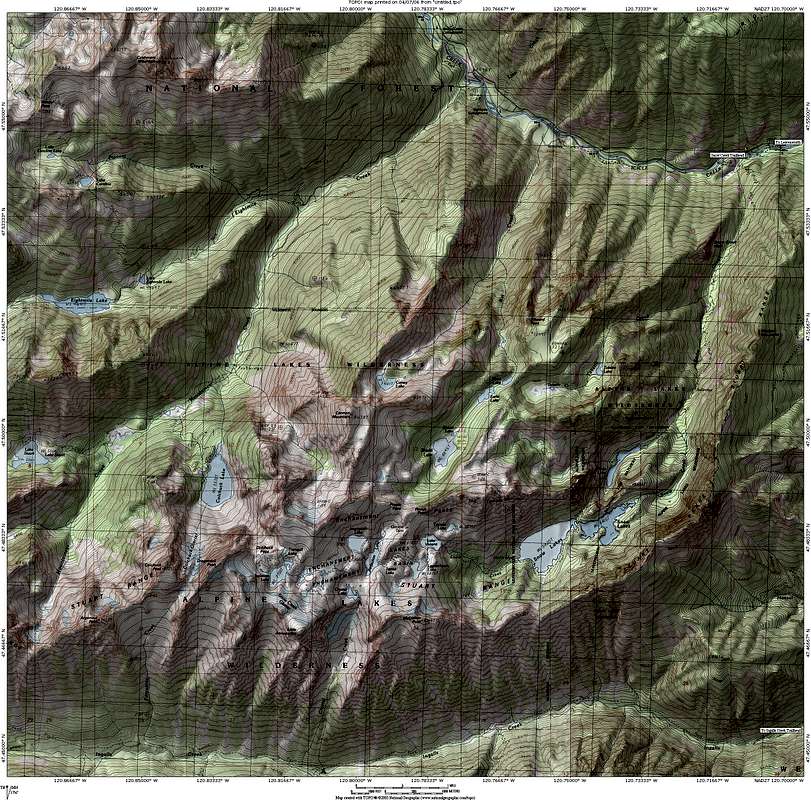
Here is link to one of the best schematic maps of the region and a link to a large scale topo map with the trail identified.
 |
| Map Courtesy of Recreation.gov and their Enchantment Lakes Permit Page |
The best laid plans don't always work out though. We arrived in Seattle on Thursday October 11th and were greeted with a changing weather pattern. For our upcoming 2 weeks in Washington, and the 10 day forecast was showing all rain.
When our big day came on Sunday the 14th, there was some pretty intense rain in Leavenworth where we were staying prior to this hike. The mountain forecast was for snow above 3000' and winds whipping at 40 mph. We decided we didn't want to start our hike in heavy rain, get all wet, and then get into the snow and the wind. We didn't have the gear or the mental preparation to make it happen!
We postponed the start of our trip until Tuesday the 16th. We couldn't delay our finish though, due to other commitments, so that meant our 3 night backpack trip was reduced to 1 night. The rain was letting up, and so was the wind. It looked like we had a narrow window to do a 1 night backpack.
 |
| A rainbow to start our trip as the rain was letting up! |
It still wasn't going to be easy. There was still a 20-30% chance of rain and it was cold and snowy at higher elevations, but the Wednesday forecast was for sun! That is all we needed to know. We started on the trail at 8 AM. A rainbow was forming to light our way. A good sign!
 |
| We're headed in! |
The trail rose steadily, climbing 600-800 feet per mile for the first 6+ miles. At about 3200' we hit the snow line. Around that time we met up with a couple groups on their way out. They told us they had intended to stay longer, but it was just too cold and windy, plus they had endured a lot of rain the first night before the snow came in.
 |
| Some forest fire damage |
At around 3800' we passed a nice campsite with a fire ring. Just beyond that was a sign saying "no campfires beyond this point". We continued on at 4900' and about 4.5 miles, we reached Nada Lake where we passed 6 designated campsites.
 |
| We were greeted with a beautiful sunrise on Wed. morning, Oct. 16th |
We wanted to get beyond Nada Lake to Snow Lake so we would have a chance to get to the Core Enchantment Zone and see some of the lakes there on Wednesday. Once we got beyond Nada Lake the trail took us up through a boulder garden. Leesa was getting tired of climbing by that point. the wind was increasing as we climbed and it was snowing and blowing. Once we reached the dam where the trail crosses between Lower and Upper Snow Lake the trail leveled off.
We had been told that the best sites on Upper Snow Lake were at the far end of the lake (western end) where the Snow Creek inlet reached the lake. It's the most sheltered area to camp, plus water is easily accessible from the inlet. Snow Lake is actually hard to access because the embankment drops steeply near the waters edge.
 |
| Good morning sunshine! |
We took one of the nice designated sites and set up our tent. Nobody else was around. Just as we finished setting up, another couple arrived and took one the campsites not too far away. Leesa set up the pads and bags inside the tent while I boiled some water for our mountain chili and some hot chocolate and tea.

By 3:45 PM we climbed in our tent for the night. There was really not place to explore with the snow squalls and blustery winds blowing through, and to stand around outside the tent, we would have just gotten cold. No fires were allowed, so we just climbed in our sleeping bags to stay warm and we fell asleep pretty quickly. On this day we had hiked 7.3 miles and climbed 4900' with our full packs. It was enough for Day 1.
 |
| A screen shot from Google Earth, looking SW, of our route on Day 1 (Blue) and Day 2 (Red), before turning around |

The night passed slowly and we both awoke many times due to wind and the snow falling onto the tent from the trees. We managed to stay in the tent until about 6:45 the next morning. I climbed out of the tent to go to the bathroom and the snow had stopped and a purple glow filled the sky prior to sunrise. It was going to be sunny!
We both got out of the tent and looked all around. It didn't look like the same place with sunshine and visibility. We took a bunch of pictures around the lake and then cooked some Ramen noodles and made some more hot chocolate. We left the tent and our big packs behind and started Day 2 with my daypack headed for the Core Enchantment Zone.
I knew we wouldn't get too far into the Core Zone because we had to return to the tent, break it down and get back to our car before dark on Day 2. The 1st highlight at the eastern end of the Core Zone is Lake Vivian, which lies at 6800' (a 1200' climb from where we had camped).
There was about 3" of snow on the ground as we headed for Lake Vivian. We climbed for awhile and reached Lake Vivian about 11:15 AM. We ran into 2 guys who had camped there overnight. They also had intended to stay longer, but they were cold and didn't want to spend another night out (that had been their 2nd night).
We looked around Lake Vivian and took lots of pictures. We didn't see any mountain goats. The area is quite famous for them, but it wasn't our morning to see them.
 |
| Lake Vivian - Just as I had pictured it to be - An awesome site |
Unfortunately, this was as far as we could go and still make it back to the car that night. We both want to go back so we can explore the whole Core Zone.
We returned to our tent, had lunch, broke down our camp and were headed back out from Upper Snow Lake with our full packs at 1:30.

We walked continuously on the way back and made it back to the car at 5:30 PM. At the car, we found that mice had gotten into some of our loose food in the front seat and they had had a feast.
We drove into Leavenworth and had a pizza and some beer from the Icicle Brewery before heading to Seattle after a great trip. Our 2 day hike was about 18 miles and close to 7000 vertical feet.
We drove into Leavenworth and had a pizza and some beer from the Icicle Brewery before heading to Seattle after a great trip. Our 2 day hike was about 18 miles and close to 7000 vertical feet.

 |
| What a difference a day makes. You could hardly see the lake the day before in the snow squall |
 |
| The view from our tent site |

 |
| Looking towards Upper Snow Lake from the dam between Upper and Lower Snow Lake |
 |
| The rock garden between Nada Lake and Lower Snow Lake |
 |
| Leesa in the rock garden |

 |
| Nada Lake |
 |
| Looked like Indian Summer down below 3000' |

Additional pictures (along with these) can also be seen on my Picasa Web Album.


