Lake George

Lake George
Lake George - from Tongue Mtn Range - 11/11/2011

Monday, April 25, 2016

Round Pond and Mud Pond - Wilcox Lake Wild Forest - 2/24/16

Just south of the wildly popular Crane Mountain lie two quiet ponds that are easily reached by short walks.  Round Pond is a 0.6 mile walk and Mud Pond is a 0.25 mile walk.  Access to the trailheads to these ponds is from Mud Pond Road (which is called Mud Pond Trail on some maps).  Most visitors to these ponds are probably intent on fishing.  


Crane Mountain from Little Pond on the drive in.

Mud Pond Road has no street sign, but it's the only road in the area.  It terminates at the site of an old farmhouse, long since removed.  A keen eye will find evidence of an old homestead:  remnants of foundations, a well house, rhododendrons, daffodils, apple trees.  This area boasts nice possible campsites that would be greater than the required 150' distance from trail, parking or water.


A remaining wellhouse.


Blue skies constrast nicely with the white birch.


A great spot for a campsite.  


Hey now....


Site of the old farmhouse.


Apple tree from the old dooryard....


Rev checking out the beaver dam en route to Round Pond.


Leesa enhancing the little beaver dam so she could cross. 


Making her way...

Once at Round Pond, we were determined to get to the peninsula on the east side of the pond known as Stony Point.  We had to cross a marsh and a couple beaver dams but we made it.  The Discover the dirondacks  - Southern Adirondacks talks about the history of this penisnsula. 


Wolf Pond Mountain from Stony Point.  WPM will be a future exploration.


Clouds were moving in as predicted and it gave some interesting skies on the way out.


Stony Point on Round Pond with Bearpen Peak in the background.

Back at the car, we drove partially back out Mud Pond Road to the Mud Pond trailhead and followed the trail downhill a quarter mile to Mud Pond where we saw 4 loons swimming near a beaver lodge in the pond.   

In the future, I'll be coming back to this area to climb some of the surrounding mountains, Cherry Ridge, Wolf Pond Mountain and Bearpen  Peak. 


Mud Pond.


A rowboat at Mud Pond.


Hike Stats:
Hike Distance:  1.8 miles (both hikes combined)
Hike Time:  1.5 hours
Total Vertical Gain:  ~250'


The routes

The route and surrounding area on the Nat Geo map.


The Exceptional Scaroon Manor Campground - Schroon Lake, NY - 4/24/16

Have you ever wandered through a New York State campground in the off-season?  Perhaps just to walk your dog, or scout it for the first time, or locate the best campsite?  We stopped at the relatively new (2011) Scaroon Manor Campground located on Route 9 straddling the Warren County/Essex County border.  The northerern campground gate is within site of the I-87 Exit 27 access road. 

Any positive adjective could be inserted for this campground and it would fit.  From our observations, it's clean and beautiful, the RV sites are well graded and easy to maneuver in and out of. There are no hookups if that is a concern.  There is a beach and of course the beautiful Schroon Lake. 

The part of the campground that especially appeals to Leesa and I is the northern end of the campground.  This is where the tent sites are, and they are huge, perhaps the largest we've ever seen. It's a very quiet area and the sites are far from Route 9, so road noise is not a problem.  In fact, you have to walk a foot trail to get to the tent sites.  The sites are not car camping sites.  The campground map can be found here.  Altogether, there are 60 tent and trailer sites at the south campground and 15 remote sites at the north campground "Camp Cayuga".

The north end is connected to the main campground (south end) by a 1.2 mile foot trail through the woods that follows Marsh Pond Creek.  You can access this foot trail by the north end parking lot without entering the campground (and you won't even feel like you are at the campground).

The frontage along Schroon Lake is a combination of campsites, woods, narrow sandy shoreline, picnic area, fishing area and boat launch.  There are open fields for ball games and activities.  Since the campground is almost new, all the facilities are in excellent condition.  Everything at this campground is fully accessible.

For history buffs, this campground was once the site of the Scaroon Manor Resort.  The old ampitheater is still intact and it will be maintained.  The draft Unit Management Plan offers a wealth of information about the history of Scaroon Manor in addition to a decription about the natural features of the area.

If you stop here yourself to take a look, you may soon forget that with 250 acres to wander, a few hours might pass before you realize it. 

The shore at the north end.


Along the north end...


The shore in the wooded section between the north and south campgrounds.

Accessible pier near the beach.


From the beach, Hoffman Mountain is visible in the backgorund (center).
  The Dix Wilderness Nippletop Mountain is just to the right.


Concrete boat basin


Ledge Hill in the background. 


The ampitheater and the later addition "projection booth".


Ampitheater backdrop


Rev being reflective?


Can you top this picnic site? 


Hoffman and the Dix Wilderness Nippletop; familiar sites to Schroon Lake residents.

If you stop here to walk your dog or scope out the campground, there is a good chance you will be back. 


Our wandering route through the campground.

Sunday, April 24, 2016

Number Seven Mountain and Ferguson Brook Falls - Lake George Wild Forest - 4/23/16

Sometimes I do a hike and then revisit the same area to bring Leesa so she can see it also.  We just did that with Bald Mountain in Warrensburg.  This time it was to Number Seven Mountain and Ferguson Brook.  

This time I started from the south at the gate where Gay Road Road meets the Hudson River.  This was my 2nd adventure of the day after hiking in the Lake Geroge/Lake Luzerne area in the morning.  Our start time was about 2 PM.   

We followed the woods road beside the Hudson River until it was time to veer into the woods to begin the bushwhack to the southern approach to Number Seven.  The final approach up the SW flank is amazing and it reminds me of the similar SW approach to Number Eight Hill in the Pharaoh Lake Wilderness Area.  Look at the pictures below and you be the judge.

We gained the ridge at the mostly flat plateau just south of the final approach.  This area was just acquired by New York State and is known as the Huckberry Mountain Forest.  If you pass through this area you will notice a maze of old logging roads. There are also still posted signed from the Number 7 Hunting Club.  


Starting the final SW approach to Number Seven Mountain


Looking back down on the Hudson River


There appeared to be a forest fire to the south of us near Lake Luzerne.


Nearing the summit.


The true summit is treed.  This is the open rock that lies about a 100 yards west of the true summit.

From the summit, we continued north until we could drop down the west face back to the river. 

Looking north along the Hudson River


A Subaru that must have encountered problems near the river, unless this was a farewell maneuver!

At the confluence of Ferguson Brook with the Hudson River, we quickly climbed along the north side of the brook to take a look at the cascades, water slides and falls.  It was almost 6 PM so we didn't have time to linger. 


No longer functional! 


It was getting late, and the wrong angle to get good pictures of the waterfall features.

We returned via the river and walked out in the setting sun.

Hike Stats:
Hike Distance:  8.3 miles
Hike Time:  5.5 hours
Total Vertical Gain:  ~ 1400'


The route

Tuesday, April 19, 2016

Sentinel Wilderness Exploration and Clements Mountain - 4/16/16

We had thought of camping in the Moose River Plains Wild Forest but we found out that the Limekiln Lake - Cedar River Road will not be open until mid-late May.  Plan B was to camp in Wilmington.  We found a great spot on Bartlett Road and set up camp on Saturday morning.

Our morning hike was an exploration of the "Cape Cod"  of the Sentinel Range Wilderness.   If you look at the shape of the Sentinel Wilderness you will see what we mean.  There is a section between Bartlett Road and the Ausable River that caught our attention.   We wanted to make a loop of this section by going east to the river, then north along the riverbank in the morning sun, followed by climbing the unnamed hill near the north end, the down the ridge back to the start.   


Our delightful campsite.  The Cobble Mountain in the background.

We followed an old jeep road shown on the topo map to get to the river.  Along the way we passed an old abandoned vehicle, a foundation and some old farming tools.


A car that hasn't moved in some time. 


Old farm tools

Soon enough we reached river where we discovered portions of an old jeep road and a herd path.
We played at the waters edge for a bit, enjoying the warm sun.  The water of course was still frigid.
   

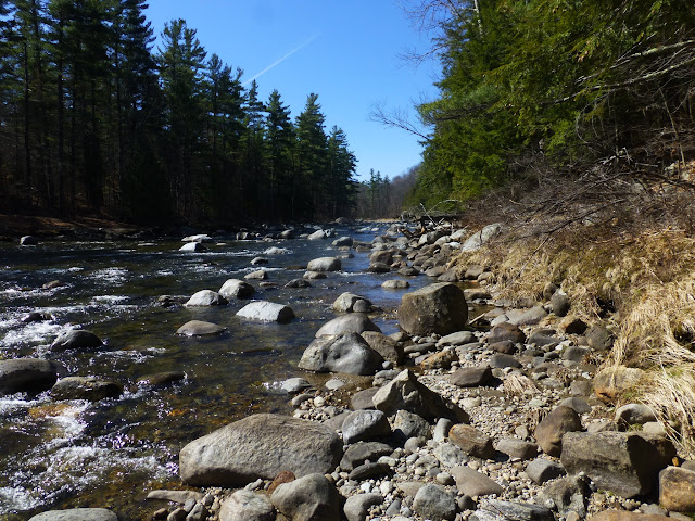
Looking south along the Ausable River.

The walk north along the river was easy and pleasant.  A little unusual for us since Route 9N was just across the river.  We are usually far from civilization.  When we drew abreast of the hill to our left, we turned and climbed the hardwood slope to the summit where we were offered views of Whiteface, Ebenezer, Pokomoonshine, Jay, Arnold and more.  These views will be gone once the trees leaf out.


The summit.  Whiteface is barely visible in the center right.


Looking north from the unnamed hill.  Ebenezer Mountain in Upper Jay is on the left.

Zoom view showing Pokomoonshine Mountain on the right.


Jay Mountain on the right, Arnold Mountain is just to the left of the col.

From the oak treed summit, we worked our way down the ridge and near the bottom we came to an open clearing with a great view of Sentinel Mountain, the Cobble Mountain, Whiteface, Pitchoff, Cascade and the Porter ridge.  


Viewpoint low on the ridge.


Whiteface Mountain


Looking up at the viewpoint.

An impressive old foundation near our campsite.

We returned to our campsite and Leesa chose to spend the afternoon there relaxing while Rev and I headed for Clements Mountain for an afternoon hike.

We headed over to Styles Brook Road and parked at the trailhead for Clements Pond.  We only went a short ways on the trail before it was time to head northeast to climb Clements via the SW flank. Once we got above around 2100' we broke into a beautiful red pine forest that lasted all the way to the summit.   

It was amazing to me that the southern part of the summit was a nice red pine forest, but as soon as I walked a little north on the summit, it turned into a thick spruce forest.  I was glad I climbed from the SW!

We returned the way we came to complete the afternoon portion of our hike.  We fed Rev at our camp spot and she snoozed while Leesa and I enjoyed a campfire on the warm spring evening.


Climbing Clements from the SW. 


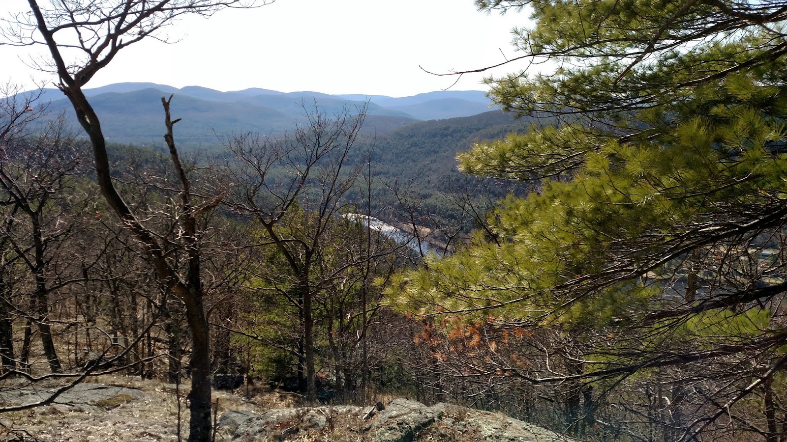
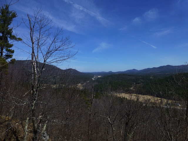
Looking south to Highland Farms and some high peaks in the back right.


Looking east.  Jay Mountain is on the left.


A viewpoint high on the SW flank of Clements.


Looking west to Whiteface.


Pretty rock and red pine.


Hike Stats:

Morning Hike off Bartlett Road:
Hike Distance:  5.4 miles
Hike Time:  3.5 hours
Total Vertical Gain:  ~800'

Clements Mountain:
Hike Distance:  2.5 miles
Hike Time:  2 hours
Total Vertical Gain:  ~ 1400'


Route for Bartlett Road Hike


Approx. route for Clements Mountain