Lake George

Lake George
Lake George - from Tongue Mtn Range - 11/11/2011

Sunday, October 25, 2015

Sleeping Beauty Mountain and Bumps Pond - Lake George Wild Forest - 10/25/15

I've climbed Sleeping Beauty many times before but I hadn't done it yet this year so it was time to climb it again.  It was warm for a late October day (50's) and there were still quite a few leaves on the trees.  It was breezy and the skies were alternating clouds with sun.

I parked at the Hogtown parking lot and didn't take a chance on driving the Dacy Clearing Road.  I could have done it with my car if I drove slow and carefully, but I hadn't seen the road in a while and didn't want to take a chance.  The road is 1.5 miles each way, so it added 30 minutes each way to my hike.


The road to Dacy Clearing.  Look at all the leaves still on the trees.


Rev in orange.  Lots of hunters were out. 


I wish I could find out the history on this foundation that is just before Dacy Clearing.

I signed in at the register at Dacy Clearing and there were a group of 21 cub scouts on the trail ahead of me.  It didn't take long to catch up to them.  I walked carefully since the old road has many "roller" rocks that were covered by leaves.

The trail from Dacy Clearing to the summit is 1.8 miles but it always seems less than that to me.  The first 0.6 miles is a slight grade before the junction with the Bumps Pond trail.  After you branch off onto the Sleeping Beauty trail, it soon begins to climb in earnest.  The trail was wet from last nights rain, but it wasn't muddy.  As I was climbing, one of the hunters in the area fired about 10 shots.  It scared Rev and she hung more closer to my side for awhile after that.  

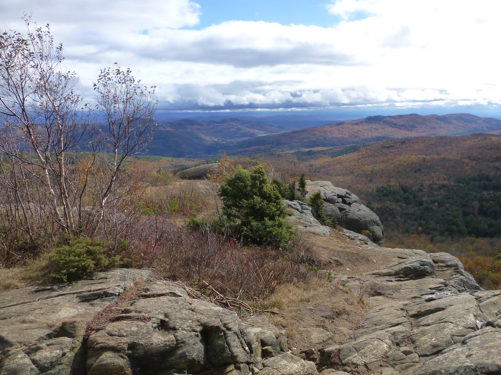
I reached the top and as always, I was reminded just how good the view is.  I was also treated to interested clouds moving across the landscape.  The pictures below can do the talking.


Fun clouds!


Heading to the lower viewpoint. 


Someone cut most of the branches off this live tree so they could try and have a fire!

I had the summit to myself for 15 minutes and then I decided to continue on to Bumps Pond.  The scouts hadn't caught up with me yet, so I moved on before they reached the top.

Bumps Pond is an additional 0.8 miles from Sleeping Beauty.  The trail is fairly rugged and this portion feels like more than 0.8.  The pond was quiet and I didn't see anyone after I left the summit of Sleeping Beauty.


Sign at Bumps Pond.
I scooted around Bumps and made my way back to Dacy Clearing.  The mixed sun and clouds and turned to all clouds.  It was nice to visit this area again and I'm sure I'll do it again next year.  


The old chimney on the west side of Bumps Pond.
Hike Stats:
Hike Distance:  7.5 miles (including Dacy Road)
Hike Timea;  2.5 hours
Total Vertical Gain: ~1300' 


The route

Fishing Brook Mountain #1 (3540') and Fishing Brook #2 (3480') - Blue Mountain Wild Forest - 10/24/15

The Fishing Brook Range lie in the Blue Mountain Wild Forest a few miles SW of the Town of Newcomb and just west of Goodnow Flow.

Fishing Brook #1 and #2 were my objectives for the day.  I got a relatively early start at 7:45 in hopes of beating any afternoon rain that might come in.  I headed for Fishing Brook Mountain first (#1).  I found the woods to be pretty easier to manuever and I found myself on the summit at 9:45 AM.    


Looking towards the High Peaks from Newcomb, pre-sunrise


A nice little 5' waterfall along the way.


The summit of Fishing Brook Mountain - 3540' 


 There was a dusting of snow all along the Fishing Brook ridge and it looked very peaceful and quiet.


Rev's orange coat stood out even more with the snow on the ground.


s
A nice zoom view of the Sewards?


Snow near the top of Fishing Brook Mountain

I left the summit and proceeded SW to work my way towards the un-named portion of the Fishing Brook range.  I dropped down to a col and went west of a my pond at the headwater of Roaring Brook.  As I climbed a small knoll, I looked up and a bull moose was on the knoll, perhaps 100 yards ahead of me!  I froze and my first thought was which camer to grab out of my pocket; my cell phone for my small travel zoom.  I reached for the travel zoom but in the 10 seconds it takes to power it up, the moose was gone.  My dog hadn't even seen it.  It continued to the knoll and all that was there was fresh moose poop and huge tracks in the snow.  It was now 10:30 AM.

I knew I probably wouldn't see it again, but I certainly would spend the rest of the hike watching for it.  I continued SW and had no problem negotiating the ridgeline.  There was no blowdown and the woods were relatively open.   Several trees along the way had moose scrapes on them.  Deer like to scrape on saplings that are an inch or two in diameter.  Moose like to scrap on young trees that are about 5 inches in diameter. 


A tree with moose scrapes.

At 11:45 AM, I reached the summit of the un-named Fishing Brook #2.  I was still overcast, but the temperature had warmed from the 20's to the 40's.  I had shed my heavier shirt and only had a techwick T-shirt on.  I was plenty warm as I moved along.


The summit of Fishing Brook #2.

Shortly after beginning my descent, the pines were gone and the woods opened up nicely.  Almost immediately I came acroos a nice hunters tree stand.  It was pretty high on the mountain.  If a hunter shot a deer here, it would have been a long drag back.  


The hunters tree stand


The woods continued to be open most of the way down.  Drainages had thicker growth near them so I stayed out of the drainages.  Two hours of easy walking and I was back at the car.

Hike Stats:
Hike Distance:  11 miles
Hike Time:  7 hours, 15 minutes
Total Vertical Gain:  ~ 3100'
  

Sunday, October 18, 2015

Cobble Ledge - Wilmington Wild Forest - 1/18/15

Last Sunday it was 70 degrees in most of the Adirondacks.  This Sunday it was 25 degrees.  Go figure.  This Sunday was still gorgeous though.  A light snowfall, combined with fall leaves and alternating snow squalls and blue skies made for fascinating scenery.

Leesa and I didn't have a whole day for adventure, but we opted to hike the new trail in Wilmington to Cobble Ledge.  We wanted to see some snow and this high elevation trail would do the trick. There was some snow around Chapel Pond and Keene Valley, so we knew we would find snow in Wilmington.


A favorite photographic viewpoint in Wilmington

Whiteface Mountain and fall colors from Springfield Road, Wilmington

Ausable River in Wilmington

We got to Wilmington and drove past the North Pole to the Wilmington Memorial Highway.  There at the entrance to the toll road were a dozen cars parked, most likely skiers earning some early season turns.  The summit of Whiteface had received 4-5 inches of snow.

At the road split for the Whiteface Highway and County Route 74, we went right on CR 74 for perhaps a quarter mile to a trailhead sign on the right.  We pulled off the shoulder and started out.


Snow even at the start of the trail.

Even though it was cold, the snow was melting in areas exposed to the sun.  We hiked through areas of snow and wintry conditions, followed by areas of leaves and fall conditions, back and forth, all the way to the ledge.
    

Fresh leaves on the ground competing with snow. 


A small stone staircase.


Back to the snow.

The elevation at the trailhead is approximately 2400'.  The trail rises a couple hundred feet before falling back to 2400' at the ledge.  The 1.2 mile long trail is perfect for familes with young children or for folks who don't want to hike a trail with a lot of elevation gain. 

We reached the ledge in 35 minutes and were greeted with changing conditions.  At first, we had visibility, but a snow squall was blowing in.  We watched our visibility disappear in a hurry. 


We arriving at the ledge and were greeted with some visibility and blowing clouds.


Mike & Rev surveying the scenery.

Before the blue skies arrived.


We roamed around a took quite a few photos.  As we were getting ready to leave, we noticed that blue skies were coming.  We decided to stay and see if  visibility was going to return.


Blue skies coming...


We're glad we waited.  This was fantastic to watch.

Within 10 minutes, we were treated to a blue sky changeover.  The snow squall stopped and skies cleared.  The blue lasted about 10 mintues before another snow squall arrived.  Still, it was long enough for us to capture the moment.  


Esther from Copper Ledge


This hike may not always be this exciting, but it's a nice short hike to a nice viewpoint.


Hike Stats:
Hike Distance:  2.4 miles
Hike Time:  1 hour, 15 minutes (plus stopping time)
Total Vertical Gain:   ~300'


The Cobble Ledge Trail (click image to enlarge)


Saturday, October 10, 2015

Blue Ridge (3497') and Blue Ridge (3436') - Blue Ridge Wilderness - 10/10/15

There are just too many mountains named Blue Ridge.  There are four on the ADK hundred highest list alone.  I had already done the one in Indian Lake and the one in Schroon, so it was time to grab these last two.

Spencer Morrissey, in his book "The Other 54", said "The twin Blue Ridges are very inviting, especially on paper, with an attractive 2.5 mile ridge between the two.  Climbing both in a day, however, would make for a trying adventure."  He admitted though that he had not tried doing this. This gave me perfect incentive to give it a go.

I got a late start and didn't get on the trail until 9 AM.  I parked at a pulloff on Cedar River Road directly south of Round Top Mountain.  My plan was to skirt the west side of Round Top, then do a counterclockwise loop of the two Blue Ridges, thereby tackling the eastern one first.

A section of the Northville Placid trail (NPT) has recently been re-routed to get it off of Cedar River Road.  It now leaves the road at Wakely Pond and goes west of Round Top en route to Stephens Pond.  This alleviates hikers from a 5 mile stretch of road walking.  Hurray!  There is still a 2.5 mile road walk, but it is better than 7.5.

I knew that I would cross the NPT as well as the old Dishrag Pond tote road pretty earlier on in my hike.  The trees were wet from rain the day before so I soaked rather quickly.  My camera also got wet so I don't have many pictures of this trip.

It took me about 15 minutes to reach the NPT and once I reached it, I followed it northward for a quarter mile or so.  Very nice re-route.  I had to leave the trail to continue my NW direction.  After 45 minutes I passed the tote road.

As I continued to climb, I passed through some sections of Witch Hobble that slowed me down a little, but I was able to avoid blowdown and thick spruce for the most part.  After 2.5 hours, I was on the summit.  I did not find any ribbon or pipe hanger remains of a cannister holder, but it was the high point of ground and it had been trod on by others.  I scouted around a bit but didn't see any other points that looked higher.

There were no views here (or anywhere during this day).  It was just a quiet day in the woods.  There were not even any chipmunks or small animals to catch Rev's attention.


Blue Ridge (3497') ... the eastern one. 


Rev had no issues going over or under blowdown.


It looks worse than it was.
Since it was not even noon yet, I set off to follow the ridge westward 3 miles to Blue Ridge (3436'). It took me another 2.5 hours to complete the ridge.  Again, the woods weren't super dense, so even though there was quite a bit of blowdown, I could walk around most of it.

This time on the summit, I found the old strap that used to hold the cannister.  Now it just held a stick that someone put there.   I was surprised that I was still not hungry or or thisty.  I made myself eat and drink a little so I wouldn't get dehydrated or lose energy.

  
Blue Ridge (3436')

It was now 2 PM and I wasn't too concerned about getting downhill before dark.  I made my way south for a short while then turned SE since the grade wasn't as steep as I thought it would be.  I skirted just north of Dishrag Pond and came back to the tote road.

This time I followed the tote road two miles until I came to where the NPT crossed, at which time I turned right and followed the NPT 0.9 miles until it was time to drop back down to Cedar River Road.  I got back to the car at 5 PM.  No views and not much in the wasy of fall color on this hike (mostly in the spruce), but two more ADK hundred highest done.  I'm up to 93 now!

A beaver pond alongside the tote road


NPT bridge over Brown Brook

Hike Stats:
Hike Distance:  11.3 miles
Hike Time:  8 hours
Total Vertical Gain:  ~2450'


The route (click imae to enlarge)